A powerful earthquake ripped through the seabed off Sarangani province in the southern Philippines on Monday morning, shaking Mindanao awake just before 7:40 and triggering tsunami warnings that spread rapidly across the region — reaching Indonesia, Japan, and Malaysia within minutes of the initial tremor.
The United States Geological Survey measured the quake at magnitude 7.8, with the epicentre located offshore near General Santos City at a depth of roughly 35 kilometres. It was felt across wide swathes of Mindanao and was strong enough to be sensed far beyond the island. More than an hour of aftershocks followed, keeping millions of people in a state of sustained alarm through the early morning hours.
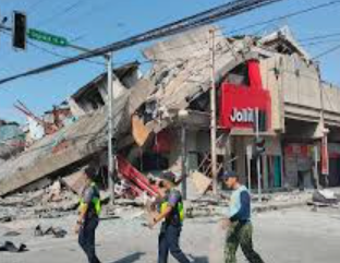
The damage on the ground was immediate and visible. In General Santos City, buildings cracked, power was knocked out across large areas, and a Jollibee restaurant collapsed entirely — one of the more striking images of the quake’s destructive force to emerge on social media. Sarangani province, where the worst of the structural damage was concentrated, is home to around 580,000 people. The police chief of Alabel town in Sarangani described watching cracks appear in his own building during the morning flag-raising ceremony as the ground moved beneath him.
At least three people were confirmed dead and four injured, according to the Philippine National Police, though authorities were clear that figures remained preliminary as first responders worked to reach more remote communities across the affected area.
The Philippine Institute of Volcanology and Seismology issued a tsunami warning almost immediately, alerting coastal communities to evacuate to higher ground without delay. Waves of between one and three metres above tide level were projected for parts of the Philippine coast. President Ferdinand Marcos Jr. addressed the nation directly, telling Filipinos in tsunami-vulnerable areas that their lives were more important than anything they might leave behind. The Philippine Coast Guard suspended all watercraft operations in Davao Occidental. Airlines cancelled flights and General Santos Airport was temporarily shut down.
Indonesia lifted its own tsunami warning roughly four and a half hours after it was issued, its meteorological agency confirming that the danger to its northern coastlines had passed. Japan and Malaysia also stood down their alerts as the threat gradually receded.
The Department of Health activated crisis protocols across its hospitals and health centres in Mindanao, deploying emergency response teams while keeping standby units in Luzon and the Visayas ready for field hospital deployment if required.
Mindanao sits at the intersection of several major tectonic fault systems on the Pacific Ring of Fire, one of the most seismically active zones on earth. The island has endured devastating earthquakes before, and Monday’s event — one of the most powerful to strike the region in years — is a reminder of how quickly and without warning the ground beneath this part of the world can move.
Assessments are ongoing. The full extent of the damage, and the final human toll, may not be known for several days.


